In the United States, the U.S. Board on Geographic Names once held the position that what defined a mountain as opposed to a hill was 1,000 feet of local relief. This was abandoned in the early 1970s due to the lack of a board agreement on this definition.

The Oxford English Dictionary defines a mountain as “a natural elevation of the earth surface rising more or less abruptly from the surrounding level and attaining an altitude which, relatively to the adjacent elevation, is impressive or notable.”


While there is a conventional understanding that a mountain is higher than a hill, there is no universally accepted definition of a mountain.

We’ve been to the Davis Mountains many times and we were ready to go back. So, a couple of weeks ago we hooked up the trailer and headed out. It’s about a 6 hour drive from our house, if we take it easy.
The Davis Mountains is the largest mountain range in Texas. It’s part of the southern Rocky Mountains and is surrounded by the Chihuahuan desert (the 2nd largest desert in North America).
The highest elevation in the Davis Mountains is 8,378-foot Mount Livermore (aka Old Baldy), the fifth-highest peak in the state.
It’s a beautiful area with gorgeous sunrises.

We always make a trip out to Balmorhea Lake. The primary purpose of the lake is storage of irrigation water, and it is owned by the local water district. It is also stocked with fish and used for recreation ($5 per car if you are birding, $5 per person if you are fishing).

It is the largest body of water in this area of Texas, and the birding here can be surprisingly good.


We enjoyed watching a Western Grebe harassing a Clark's Grebe that had caught a very small fish. The Clark's Grebe was not in the mood to share!


We also saw a group of Scaled Quail chicks running through the grass, their mother not far behind!


Another place we like to visit is the Chihuahuan Desert Nature Center.


A new bird blind has been built since we were here last (Feb. 2020).


There is a extensive trail system. In years past, we have hiked all the trails.

We picked a trail for a little hiking. The trail started out nice and flat. It didn’t stay that way for long. It quickly turned into a rocky, steep incline.

There are some pretty amazing views from the top and a nice interpretive area.


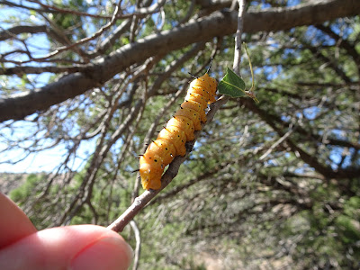
On the way down we ran into these amazing eating machines.

One day we drove "The Big Loop" which is a 75 mile route that circles the tallest mountain in the area and passes through some beautiful country.


There is virtually no traffic on the route, which makes it very easy to bird along the road.

During this stop we were able to watch and photograph a Phainopepla. They are the only member of the Silky-flycatcher family found within the United States. The rest of the family lives in Central America.

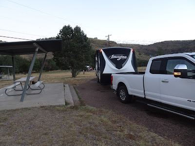
I forgot to get a picture of our site when we arrived. So, while Mark was setting the GPS and all the other gadgets before we left, I hopped out and got a picture.
I did buy one souvenir. It’s not a magnet but I’m going to glue a magnet on the back and slap it on the refrigerator. We stopped at Balmorhea State Park after visiting Balmorhea Lake.

While we were camping in the park we met a nice couple who were interested in birds, and especially in photography. We spent some time with them, and they got us interested in trying to get pictures of the rising full moon. Here is one that came out well.

Stay tuned. We’re on to our next adventure.

Although we didn't explore the park, we did go through the area when we went from Las Cruces to Hueco Tanks. Will moon pictures become a new photography hobby?
ReplyDeleteProbably only a "once-in-a-while" thing. The interesting thing about this location was the moon rising over a ridge, with the tree available to silhouette. Most places we visit don't offer this type of terrain.
DeleteNice post and great pictures as usual.
ReplyDeleteCan't wait to hear about the next adventure.
Thank you!
DeleteNew post next week.
I really like the Phainopepla. Dont think I ever saw one.
ReplyDeleteI keep the Western and Clark straight by thinking of an outlaw from out WEST. They cover their eyes, hence Western.
That is a great way to remember the Western!
Delete