The Lava Falls Trail follows the top of the McCarty Lava Flow, named after a small, nearby town. The lava flow is "only" 3000 years old, which is young in the span of geologic time. Most of the exposed surface is solidified lava, with only small amounts of grasses and trees growing in cracks and crevices.
Designating the trail must have been difficult, as you can't really create any sort of pathway. So they rely on rock cairns, which are simply small piles of rock. You walk from one cairn to the next. The trail guide warns you not to leave one cairn until you've spotted the next one. The landscape is very confusing and it would be easy to get hopelessly lost out on the lava.
In the picture above I am standing just behind a cairn. The next is about 50 feet ahead, just along the deep crack (click on the picture for a bigger view). They blended in well so trail finding was a little tricky in spots.
The trail surface was an interesting combination of rough rock and loose cinders. The cinders were lightweight pebbles formed by gassy lava cooling while still in the air. Very crunchy to walk on!
So what about the name of the trail, Lava Falls? If you were expecting to see a 100 foot waterfall of lava you'd be disappointed, but there were several areas where molten lava had poured over a ridge and hardened, leaving a lava fall.
There were several other textures of lava. "Ropey Pahoehoe" was a common texture on the trail. Pahoehoe is a Hawaiian term for relatively smooth lava. It looks a bit like a lava fall, but is flatter.
"Lava Toes" are lobes of lava that are formed when hot lava breaks out of semi-hardened lava.
Here is a place where a slab of lava hardened, and then got pushed in such a way that it buckled upward. This looks like a good place for a lizard to hang out!
This is a tough environment for either plants or animals to survive. In one area we found this "Pygmy Forest" of twisted, stunted Ponderosa and Pinion Pines. By putting their roots down into the cracks they can find enough water and nutrients to survive, but they will never grow to the heights of trees found off of the lava.
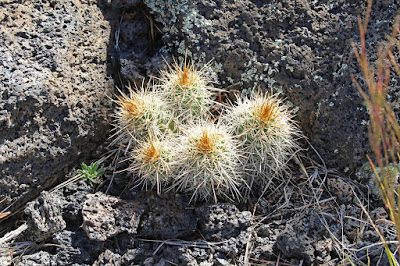
Other tough plants included some beautiful cactus tucked down in the lava.
This was a fascinating hike over an unusual and barren landscape. We had on sturdy hiking boots, but our trail guide asked us to imagine what it would have been like to cross these lava flows in yucca sandals like the Native Americans. Hard to imagine...
Mark


Lava flows and trails are always so interesting! Looking forward to adding that one to the list.
ReplyDeleteThat has got to be some list!!
DeleteThis comment has been removed by the author.
ReplyDeleteThat sounds like s great hike. I see Serene has added it to the list.
DeleteWe were pleasantly surprised by the entire area. Worth the trip!
Delete